

Loganville Braces for Weekend Storm as Kemp Declares State of Emergency |
Hurricane Isaias could bring heavy rain, damaging wind gusts and isolated tornadoes to Walton and Gwinnett counties; Monroe’s Fall Fest has been canceled. |
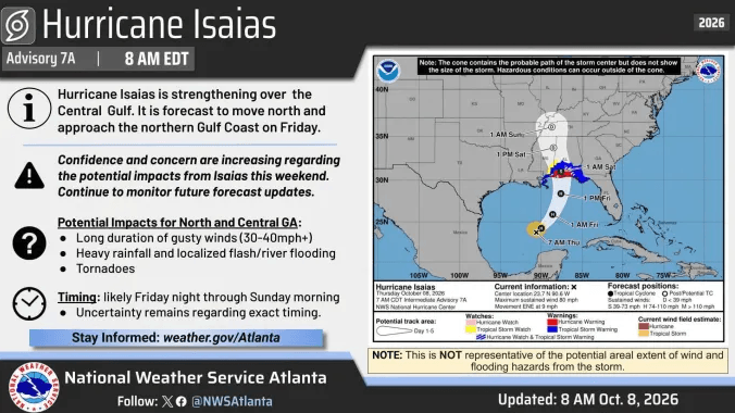
Loganville residents should prepare for possible power outages, flooded roads and hazardous weather this weekend as Hurricane Isaias approaches the Gulf Coast and threatens communities across Georgia.
Gov. Brian Kemp issued an updated state of emergency for all 159 counties Thursday, October 8, allowing emergency officials to position personnel and resources ahead of the storm. The Georgia Emergency Management and Homeland Security Agency’s State Operations Center is scheduled to activate early Friday afternoon.
For the Loganville area, the main concerns are repeated rounds of heavy rain, prolonged gusty winds and the possibility of tornadoes. The National Weather Service in Peachtree City expects impacts across north and central Georgia from Friday night into Sunday morning.
Walton and Gwinnett counties are included in a Flood Watch beginning late Friday night and continuing through Sunday morning. Forecasters anticipate widespread rainfall totals of 1 to 3 inches, with isolated locations potentially receiving around 5 inches.
The greatest flooding concerns involve low-lying neighborhoods, roads with poor drainage and creeks or streams that rise quickly during heavy rain. Repeated rainbands passing over the same locations could increase the flash-flood threat. Residents in flood-prone areas should be ready to act if warnings are issued or water begins rising.
A High Wind Watch also covers Walton and Gwinnett from Saturday morning through Sunday morning. The watch calls for possible east winds of 15 to 25 mph, with gusts reaching 50 mph.
Those winds could bring down trees and power lines, potentially causing widespread outages. Travel may become difficult, especially for drivers of trucks, vans and other high-profile vehicles.
Saturday is shaping up to be the most disruptive day of the weekend. The National Weather Service’s Loganville forecast calls for rain throughout the day, with thunderstorms possible later Saturday and Saturday night. Showers and thunderstorms could linger into Sunday before rain chances gradually decrease.
The approaching storm has already affected local plans. The City of Monroe canceled its Fall Fest scheduled for Saturday, October 10, citing safety concerns for visitors, vendors, volunteers and participants. The event will not be rescheduled this year because of the city’s remaining calendar commitments.
Residents can use the time before conditions deteriorate to gather drinking water, nonperishable food, flashlights and batteries. Kemp urged Georgians to prepare now for potential severe weather Friday night and Saturday.
Around the house, secure patio furniture, trash cans, decorations and other loose outdoor items. Review your family’s communication plan and identify where everyone will shelter if a tornado warning is issued. GEMA recommends a basement or small interior room away from windows; if flooding threatens that location, move to a safe area above the rising water.
During the storm, avoid water-covered roads and never drive around barricades. Stay away from fallen power lines, and keep monitoring official alerts even if the rain or wind briefly eases.
The current watches identify the potential for dangerous conditions; they do not mean every neighborhood will experience flooding or damaging winds. Forecast details and alert coverage can change as the storm approaches.
Residents should follow the National Weather Service in Peachtree City and local emergency management announcements throughout the weekend. Those attending football games, festivals or other outdoor activities should also check directly with organizers before leaving home.
Updated Thursday afternoon, October 8, 2026. |
4 Comments
Join the conversation
Sad about Monroe Fall Fest. We go every year!
50 mph gusts? Bringing the porch chairs inside tonight.
Dave ThompsonI'm bringing in the trash cans too. Those always seem to go first.
Walton's flood watch has me moving the car uphill.